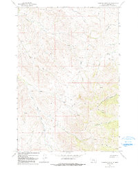
1967 Map of Thompson Creek NW
USGS Topo · Published 1991About this map
The Wolf Mountains dominate the southern half of this landscape within the Crow Indian Reservation, as documented by fieldwork in the late 1960s. The terrain is defined by an intricate network of drainage systems, most notably Reno Creek and its various branches, including the North Fork Reno Creek and South Fork Reno Creek. This region is sparsely settled, with the map focusing on the natural topography and the numerous Springs that sustain the local watershed.
Find a feature on this map
13 named features on this map. Tap any name to fly to it.
Don’t see what you’re looking for? This feature index may not catch every label — zoom into the map to look around manually.
Map Details
Editions of this 1967 Thompson Creek NW Map
2 editions found
Other maps of this area

1894 · Rosebud
USGS Topo · 1:125,000

1901 · Rosebud
USGS Topo · 1:125,000

1954 · Hardin
USGS Topo · 1:250,000

1957 · Hardin
USGS Topo · 1:250,000

1958 · Hardin
USGS Topo · 1:250,000

1967 · Crow Agency SE
USGS Topo · 1:24,000

1967 · Lodge Grass NE
USGS Topo · 1:24,000

1967 · Wolf Mountain Lookout
USGS Topo · 1:24,000
1967 · Jeans Fork SE
USGS Topo · 1:24,000
1967 · Thompson Creek
USGS Topo · 1:24,000