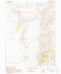
1991 Map of Thompson Knoll
USGS Topo · Published 1991About this map
The Confusion Range dominates the eastern landscape of this Millard County interior, showing the stark transition into the Ferguson Desert to the southwest. This 1991 provisional survey, based on field checks from 1989, documents a region defined by arid hydrology and sparse resource extraction. Water management is critical in this environment, evidenced by the Thompson Knoll Reservoir near the topographic feature of Thompson Knoll and the Conger Reservoir to the north. Movement through the area is restricted to the Valley Road within Little Valley and various 4wd tracks that penetrate the canyons. Notable landforms such as Boobs Canyon and Center Canyon carve into the mountain front, while a Gravel Pit indicates localized industrial activity near the Sheepmens area.
Find a feature on this map
18 named features on this map. Tap any name to fly to it.
Don’t see what you’re looking for? This feature index may not catch every label — zoom into the map to look around manually.
Map Details
Editions of this 1991 Thompson Knoll Map
This is the sole edition of this map. No revisions or reprints were ever made.
Other maps of this area

1908 · Fish Springs
USGS Topo · 1:250,000

1910 · Fish Springs
USGS Topo · 1:250,000

1953 · Richfield
USGS Topo · 1:250,000

1953 · Delta
USGS Topo · 1:250,000

1958 · Richfield
USGS Topo · 1:250,000

1958 · Delta
USGS Topo · 1:250,000

1960 · Conger Range
USGS Topo · 1:62,500

1960 · Burbank Hills
USGS Topo · 1:62,500

1960 · Crystal Peak
USGS Topo · 1:62,500

1960 · Conger Mountain
USGS Topo · 1:62,500