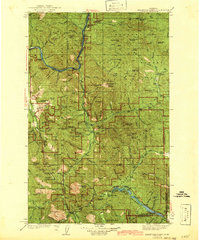
1942 Map of Thompson Lakes
USGS Topo · Published 1942About this map
The Fisher River and Thompson River drainage systems define this section of the Kootenai National Forest and Cabinet National Forest as it was surveyed in the mid-1930s. The Great Northern Railway tracks follow the winding course of the Kootenai shoreline, connecting small settlements like Warland and Jennings to the broader rail network. This era shows a landscape managed by a network of fire lookouts and ranger stations, including Big Swede Pk Lookout, Alexander Mtn Lookout, and the Wolf Cr Guard Sta. Local education and community life are marked by remote outposts such as Pleasant Valley Sch and Marnicke Sch. Geologic interest is found at Zonolite Mtn, while recreational or resource-heavy areas are centered around Loon Lake, Crystal Lake, and McMinn Meadows.
Find a feature on this map
107 named features on this map. Tap any name to fly to it.
Don’t see what you’re looking for? This feature index may not catch every label — zoom into the map to look around manually.
Map Details
Editions of this 1942 Thompson Lakes Map
2 editions found

Other maps of this area

1913 · Stryker
USGS Topo · 1:125,000

1916 · Stryker
USGS Topo · 1:125,000

1920 · Libby
USGS Topo · 1:125,000

1920 · Jennings
USGS Topo · 1:125,000

1930 · Libby
USGS Topo · 1:125,000

1932 · Libby
USGS Topo · 1:125,000

1932 · Trout Creek
USGS Topo · 1:125,000

1935 · Thompson Lakes
USGS Topo · 1:96,000

1935 · Trout Creek
USGS Topo · 1:125,000

1936 · Trout Creek
USGS Topo · 1:125,000