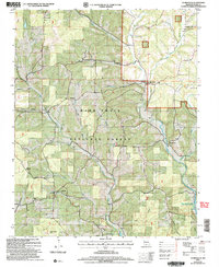
2004 Map of Thornfield
USGS Topo · Published 2006About this map
Mark Twain National Forest dominates this section of the Missouri Ozarks, characterized by a complex network of hollows and ridges. Small settlements like Thornfield and Hammond are situated near the Little North Fork White River, while Pondfork and Longrun sit further west among the upland terrain. The map provides significant genealogical value through its many rural burial sites, including Welsh Cem, Truevine Cem, Graham Cem, and Wallace Cem. High points such as Washington Bald and the Panorama Viewpoint offer vantage points along the Glade Top Scenic Byway. To the southeast, the terrain descends toward the waters of Bull Shoals Lake, which occupies the valley where several creeks, such as Turkey Creek, converge. The landscape is a mix of wooded national forest land and isolated homesteads connected by winding secondary roads.
Find a feature on this map
33 named features on this map. Tap any name to fly to it.
Don’t see what you’re looking for? This feature index may not catch every label — zoom into the map to look around manually.
Map Details
Editions of this 2004 Thornfield Map
This is the sole edition of this map. No revisions or reprints were ever made.
Other maps of this area

1936 · Thornfield
USGS Topo · 1:48,000

1936 · Ava
USGS Topo · 1:48,000

1937 · Bradleyville
USGS Topo · 1:48,000

1942 · Ava
USGS Topo · 1:62,500

1943 · Protem
USGS Topo · 1:62,500

1943 · Thornfield
USGS Topo · 1:62,500

1943 · Bradleyville
USGS Topo · 1:62,500

1945 · Ava
USGS Topo · 1:62,500

1945 · Harrison
USGS Topo · 1:250,000

1945 · Thornfield
USGS Topo · 1:62,500