
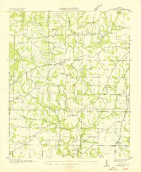
1936 Map of Thorntontown
USGS Topo · Published 1936About this map
Wheeler Reservoir dominates this 1936 survey, illustrating a landscape in transition as the Tennessee Valley Authority projects reshaped the region. This advance sheet captures the inundation of the Tennessee River, marking submerged landmarks such as Former Lock No 1 and numerous Former Islands beneath the new water levels. Along the northern shoreline, the settlement of Rogersville and the namesake Thorntontown sit near the Lee Highway US No 72, serving as anchors for the surrounding rural communities.
Find a feature on this map
45 named features on this map. Tap any name to fly to it.
Don’t see what you’re looking for? This feature index may not catch every label — zoom into the map to look around manually.
Map Details
Editions of this 1936 Thorntontown Map
This is the sole edition of this map. No revisions or reprints were ever made.
Other maps of this area

1914 · Rogersville
USGS Topo · 1:48,000

1916 · Rogersville
USGS Topo · 1:62,500

1936 · Union Hill
USGS Topo · 1:24,000

1936 · Courtland
USGS Topo · 1:24,000

1936 · Lexington
USGS Topo · 1:24,000

1936 · Hillsboro
USGS Topo · 1:24,000

1936 · Wheeler Dam
USGS Topo · 1:24,000

1936 · Town Creek
USGS Topo · 1:24,000
1936 · Center Hill
USGS Topo · 1:24,000

1936 · Cairo
USGS Topo · 1:24,000