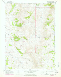
1965 Map of Three Forks
USGS Topo · Published 1979About this map
Three Forks anchors this high-elevation landscape in the late 1960s, where the drainages of the North Fork and South Fork meet. The terrain is defined by its water sources and resource extraction markers, including several Prospects and a specific Claypit located near Whitney Canyon. Named landmarks such as Christensen Hollow and Acocks Canyon suggest the heritage of local ranching or early land use, while a network of Jeep Trails provides the primary access through the steep topography.
Find a feature on this map
24 named features on this map. Tap any name to fly to it.
Don’t see what you’re looking for? This feature index may not catch every label — zoom into the map to look around manually.
Map Details
Editions of this 1965 Three Forks Map
3 editions found
Other maps of this area

1912 · Randolph
USGS Topo · 1:125,000

1954 · Ogden
USGS Topo · 1:250,000

1958 · Ogden
USGS Topo · 1:250,000

1960 · Ogden
USGS Topo · 1:250,000

1962 · Sawtooth Mountain
USGS Topo · 1:24,000

1962 · Bell Butte
USGS Topo · 1:24,000

1965 · Evanston
USGS Topo · 1:24,000

1965 · Little Dee Creek
USGS Topo · 1:24,000

1965 · Guild Hollow
USGS Topo · 1:24,000

1965 · Three Forks
USGS Topo · 1:24,000