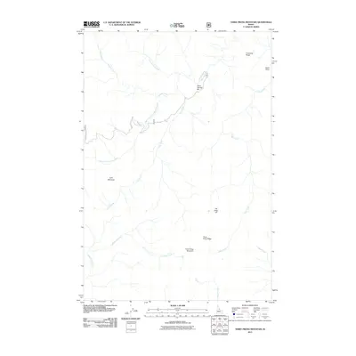
2011 Map of Three Prong Mountain
USGS Topo · Published 2011About this map
Three Prong Mountain and its surrounding drainage systems define this Idaho County landscape, where deep canyons and high ridges dictate the movement of both water and traveler. The convergence of Running Creek and its many tributaries, including the South Fork Running Creek, creates a complex network of waterways that has historically shaped navigation through this high-elevation terrain. At Warm Springs Bar, the confluence with Warm Springs Creek marks a rare level landing amidst the steep slopes of Parachute Ridge and the dramatic topography of The Drop-off. Further south, the high ground of Three Prong Ridge overlooks Bargamin Creek, while Lynx Meadows provides a distinct break in the heavy timber. This 2011 survey documents the specific routes through the area, including Running Creek Rd and Rd 357, which provide essential access for forest management and local transit between the peaks and creek beds.
Find a feature on this map
18 named features on this map. Tap any name to fly to it.
Don’t see what you’re looking for? This feature index may not catch every label — zoom into the map to look around manually.
Map Details
Editions of this 2011 Three Prong Mountain Map
This is the sole edition of this map. No revisions or reprints were ever made.
Other maps of this area

1956 · Elk City
USGS Topo · 1:250,000

1960 · Elk City
USGS Topo · 1:250,000

1966 · Spot Mountain
USGS Topo · 1:24,000

1966 · Green Mtn.
USGS Topo · 1:24,000

1966 · Three Prong Mountain
USGS Topo · 1:24,000
1966 · Wylies Peak
USGS Topo · 1:24,000
1966 · Gardiner Peak
USGS Topo · 1:24,000
1966 · Running Lake
USGS Topo · 1:24,000

1978 · Spread Creek Point
USGS Topo · 1:24,000

1978 · Magruder Mtn
USGS Topo · 1:24,000