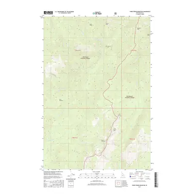
2017 Map of Three Prong Mountain
USGS Topo · Published 2017About this map
Nez Perce National Forest and the Bitterroot National Forest converge in this high-altitude wilderness, defined by a complex network of ridgelines and creek drainages. The topography is dominated by prominent features like Three Prong Mtn, Parachute Ridge, and Patrol Ridge, which oversee the steep descents toward the central watercourses. Low-lying areas such as Warm Springs Bar and Lynx Meadows offer rare breaks in the vertical landscape, while the aptly named The Drop-off suggests the challenging nature of the local terrain. Movement through the area is largely dictated by the water, following Warm Springs Cr, Running Cr, and Bargamin Cr. A single corridor, Running Creek Rd, provides limited access into this interior section of the Idaho backcountry, where natural landmarks like Eagle Point serve as primary navigational anchors for those traversing the forest boundaries.
Find a feature on this map
25 named features on this map. Tap any name to fly to it.
Don’t see what you’re looking for? This feature index may not catch every label — zoom into the map to look around manually.
Map Details
Editions of this 2017 Three Prong Mountain Map
This is the sole edition of this map. No revisions or reprints were ever made.
Other maps of this area

1956 · Elk City
USGS Topo · 1:250,000

1960 · Elk City
USGS Topo · 1:250,000

1966 · Spot Mountain
USGS Topo · 1:24,000

1966 · Green Mtn.
USGS Topo · 1:24,000

1966 · Three Prong Mountain
USGS Topo · 1:24,000
1966 · Wylies Peak
USGS Topo · 1:24,000
1966 · Gardiner Peak
USGS Topo · 1:24,000
1966 · Running Lake
USGS Topo · 1:24,000

1978 · Spread Creek Point
USGS Topo · 1:24,000

1978 · Magruder Mtn
USGS Topo · 1:24,000