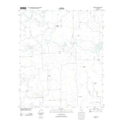
2013 Map of Thrifty
USGS Topo · Published 2013About this map
Thrifty and the surrounding ranchlands of Brown County are defined by the winding course of Jim Ned Cr as it flows toward the western reaches of Lake Brownwood. The landscape is a network of intermittent waterways like Mud Cr, Little Mud Cr, and Sand Cr that drain the local uplands. Notable elevations such as Indian Mtn, Mayberry Mtn, and the stretch of Cedar Ridge break the horizon, providing landmarks for the rural communities of Fry, Buffalo, and Blackwell Crossing.
Find a feature on this map
57 named features on this map. Tap any name to fly to it.
Don’t see what you’re looking for? This feature index may not catch every label — zoom into the map to look around manually.
Map Details
Editions of this 2013 Thrifty Map
This is the sole edition of this map. No revisions or reprints were ever made.
Other maps of this area

1887 · Coleman
USGS Topo · 1:125,000

1889 · Coleman
USGS Topo · 1:125,000

1924 · Coleman 1-a
USGS Topo · 1:48,000

1924 · Brownwood Reservoir Site
USGS Topo · 1:48,000

1927 · Grosvenor
USGS Topo · 1:62,500

1954 · Brownwood
USGS Topo · 1:250,000
1960 · Coleman NE
USGS Topo · 1:24,000
1960 · Burkett
USGS Topo · 1:24,000
1962 · Bangs East
USGS Topo · 1:24,000

1962 · Santa Anna
USGS Topo · 1:24,000