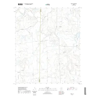
2019 Map of Thrifty
USGS Topo · Published 2019About this map
Jim Ned Creek meanders through the heart of this Central Texas landscape along the border of Coleman and Brown counties. This agricultural and ranching region is defined by a network of drainage ways including Mud Creek and Sand Creek, which flow toward the eastern hills. The tiny community of Thrifty sits near the eastern edge of the quadrangle, while several burial grounds, including Mud Creek Cem, Salem Cem, and Fairview Cem, are scattered across the rural countryside. Elevations rise significantly at prominent landmarks like Indian Mtn and Mayberry Mtn. The infrastructure reflects a blend of modern travel on FM 585 and deep-rooted pathways like Old Comanche Rd, illustrating how historic transit routes shaped the development of these rural Texas holdings near Gobbler Hollow.
Find a feature on this map
59 named features on this map. Tap any name to fly to it.
Don’t see what you’re looking for? This feature index may not catch every label — zoom into the map to look around manually.
Map Details
Editions of this 2019 Thrifty Map
This is the sole edition of this map. No revisions or reprints were ever made.
Other maps of this area

1887 · Coleman
USGS Topo · 1:125,000

1889 · Coleman
USGS Topo · 1:125,000

1924 · Coleman 1-a
USGS Topo · 1:48,000

1924 · Brownwood Reservoir Site
USGS Topo · 1:48,000

1927 · Grosvenor
USGS Topo · 1:62,500

1954 · Brownwood
USGS Topo · 1:250,000
1960 · Coleman NE
USGS Topo · 1:24,000
1960 · Burkett
USGS Topo · 1:24,000
1962 · Bangs East
USGS Topo · 1:24,000

1962 · Santa Anna
USGS Topo · 1:24,000