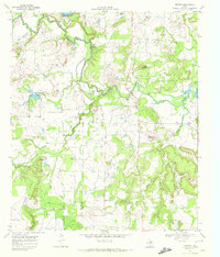
1969 Map of Thrifty
USGS Topo · Published 1972About this map
Jim Ned Creek winds across the northern landscape of this Central Texas region, defining a terrain shaped by water and energy. The 1969 field survey documents a rural economy where petroleum extraction and livestock ranching intersect, marked by the extensive Oil Field and an Indefinite Boundary between Coleman and Brown Counties. Settlements like Thrifty and the small locale of Buffalo serve as anchors for the surrounding agricultural community, while the presence of Eureka Ch and Salem Cem provides essential touchpoints for genealogical research. Prominent local landmarks such as Indian Mountain and Mayberry Mountain rise above the drainage basins of Sand Creek and Mud Creek. Infrastructure of the era is clearly visible, including a Pumping Sta, a Landing Strip, and numerous gravel and clay pits, illustrating the mid-century industrial footprint on the West Texas plains.
Find a feature on this map
24 named features on this map. Tap any name to fly to it.
Don’t see what you’re looking for? This feature index may not catch every label — zoom into the map to look around manually.
Map Details
Editions of this 1969 Thrifty Map
This is the sole edition of this map. No revisions or reprints were ever made.
Other maps of this area

1887 · Coleman
USGS Topo · 1:125,000

1889 · Coleman
USGS Topo · 1:125,000

1924 · Coleman 1-a
USGS Topo · 1:48,000

1924 · Brownwood Reservoir Site
USGS Topo · 1:48,000

1927 · Grosvenor
USGS Topo · 1:62,500

1954 · Brownwood
USGS Topo · 1:250,000
1960 · Coleman NE
USGS Topo · 1:24,000
1960 · Burkett
USGS Topo · 1:24,000
1962 · Bangs East
USGS Topo · 1:24,000

1962 · Santa Anna
USGS Topo · 1:24,000