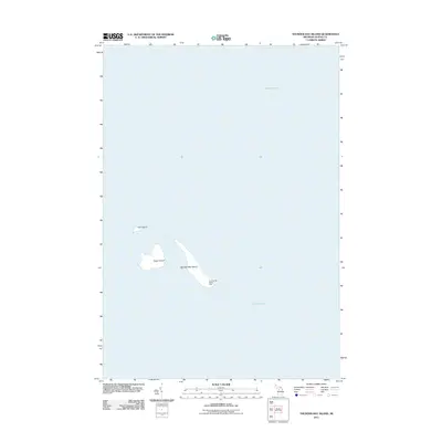
2011 Map of Thunder Bay Island
USGS Topo · Published 2011About this map
Thunder Bay Island Light stands as the primary navigational landmark in this maritime survey of the Lake Huron waters east of Alpena. The map is defined by a cluster of small islands that have long served as critical markers for shipping traffic entering the bay. Thunder Bay Island and its smaller neighbors, Sugar Island and Gull Island, appear here amidst the open expanse of Lake Huron. The isolation of these landforms from the Michigan mainland highlights their historical role in Great Lakes maritime safety, with the light station acting as a sentinel for the rocky shallows and shipping lanes that define this portion of the coastline.
Find a feature on this map
5 named features on this map. Tap any name to fly to it.
Don’t see what you’re looking for? This feature index may not catch every label — zoom into the map to look around manually.
Map Details
Editions of this 2011 Thunder Bay Island Map
This is the sole edition of this map. No revisions or reprints were ever made.
Other maps of this area

1954 · Tawas City
USGS Topo · 1:250,000

1954 · Alpena
USGS Topo · 1:250,000

1957 · Alpena
USGS Topo · 1:250,000

1958 · Alpena
USGS Topo · 1:250,000

1958 · Tawas City
USGS Topo · 1:250,000

1969 · Alpena
USGS Topo · 1:250,000
1971 · Thunder Bay Island
USGS Topo · 1:24,000

1971 · Middle Island
USGS Topo · 1:24,000

1971 · North Point
USGS Topo · 1:24,000
1971 · South Point
USGS Topo · 1:24,000