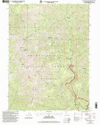
1998 Map of Thurston Peaks
USGS Topo · Published 2003About this map
Trinity Alps Wilderness and the surrounding Shasta Trinity National Forest define this landscape of the late 1990s. The terrain is structured by massive geologic features such as Limestone Ridge and Backbone Ridge, which dictate the paths of the North Fork Trinity River and the South Fork East Fork Trinity River. Human presence is marked by a network of high-elevation campsites and cabins, including Stronce Cabin and Jakes Upper Camp.
Find a feature on this map
49 named features on this map. Tap any name to fly to it.
Don’t see what you’re looking for? This feature index may not catch every label — zoom into the map to look around manually.
Map Details
Editions of this 1998 Thurston Peaks Map
2 editions found
Other maps of this area

1909 · Big Bar
USGS Topo · 1:96,000

1915 · Big Bar and Vicinity
USGS Topo · 1:250,000

1948 · Weed
USGS Topo · 1:250,000

1950 · Weed
USGS Topo · 1:250,000

1951 · Helena
USGS Topo · 1:62,500

1951 · Ironside Mountain
USGS Topo · 1:62,500

1955 · Salmon Mtn
USGS Topo · 1:62,500

1955 · Cecilville
USGS Topo · 1:62,500

1958 · Redding
USGS Topo · 1:250,000

1958 · Weed
USGS Topo · 1:250,000