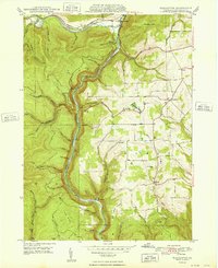
1948 Map of Tiadaghton
USGS Topo · Published 1948About this map
Pine Creek carves a deep gorge through the center of this 1940s survey, dictating the course of the New York Central railroad and defining the settlement patterns of Tioga County. The map captures a landscape defined by sharp elevation shifts between the plateau and the creek bed, with specific landmarks like Harrison Lookout and Colton Point providing vantage points over the narrow valley. While the gorge itself remains largely undeveloped, the surrounding uplands support small rural communities and local institutions. Genealogy researchers will find significant value in the mapped locations of the Middle Ridge Ch, Sherman Sch, and the West Branch Cem near Olesville. Small clusters of homes and buildings are documented at Ansonia, Stowell, and Tiadaghton, illustrating the dispersed nature of Pennsylvania's ridge-and-valley settlements during the post-war era.
Find a feature on this map
55 named features on this map. Tap any name to fly to it.
Don’t see what you’re looking for? This feature index may not catch every label — zoom into the map to look around manually.
Map Details
Editions of this 1948 Tiadaghton Map
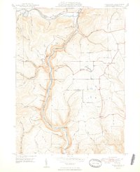
2 editions found
Other maps of this area

1899 · Gaines
USGS Topo · 1:62,500

1900 · Gaines
USGS Topo · 1:62,500

1900 · Elkland
USGS Topo · 1:62,500

1946 · Tiadaghton
USGS Topo · 1:24,000

1946 · Antrim
USGS Topo · 1:62,500

1946 · Cedar Run
USGS Topo · 1:24,000

1946 · Antrim
USGS Topo · 1:24,000

1946 · Morris
USGS Topo · 1:24,000

1947 · Galeton
USGS Topo · 1:62,500

1947 · Lee Fire Tower
USGS Topo · 1:24,000
Featured Places
- Morris Township, PA
- Gaines Township, PA
- Tiadaghton, Delmar Township
- Delmar Township, PA
- Elk Township, PA