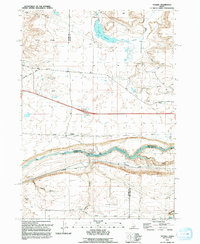
1992 Map of Ticeska
USGS Topo · Published 1992About this map
Ticeska sits at the center of this 1990s-era topographic study, marking a high-desert landscape defined by the deep carving of the Snake River. This region, where the borders of Elmore, Gooding, and Twin Falls counties converge, demonstrates the intricate management of water in the arid West. The river is harnessed at the Bliss Dam and its associated Powerplant, forming the Bliss Reservoir which snakes through the canyon floor. To the north, the terrain transitions into the high flats of Burnt Ridge and Gopher Knoll, where a system of infrastructure including Pioneer Reservoir, a Canal, and a Ditch network supports the land. Local transport is represented by descriptive routes such as Main Shoestring Road and Gopher Road, while drainage features like Tuana Gulch and Clover Creek shape the descent toward the river valley.
Find a feature on this map
30 named features on this map. Tap any name to fly to it.
Don’t see what you’re looking for? This feature index may not catch every label — zoom into the map to look around manually.
Map Details
Editions of this 1992 Ticeska Map
This is the sole edition of this map. No revisions or reprints were ever made.
Other maps of this area

1892 · Camas Prairie
USGS Topo · 1:125,000

1893 · Camas Prairie
USGS Topo · 1:125,000

1947 · Pasadena Valley
USGS Topo · 1:24,000

1948 · Pasadena Valley
USGS Topo · 1:24,000

1948 · Twentymile Butte
USGS Topo · 1:24,000

1948 · Ticeska
USGS Topo · 1:24,000

1949 · Ticeska
USGS Topo · 1:24,000

1949 · Pasadena Valley
USGS Topo · 1:62,500

1949 · Bliss
USGS Topo · 1:24,000

1949 · Hagerman
USGS Topo · 1:24,000