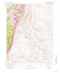
1954 Map of Tidwell Bottoms
USGS Topo · Published 1981About this map
Tidwell Bottoms forms the center of this remote desert landscape, where the San Rafael River cuts through the high plateaus of Sinbad Country. The 1950s survey captures a geography defined by seasonal water and cattle ranching, marked by family-named sites such as Gillies Ranch and the outlier known as The Frenchmans. Water management is the primary human imprint on the land, evidenced by small-scale irrigation and stock water projects like Buckmaster Reservoir, Hatt Reservoir, and Ninemile Reservoir. Notable terrain features like Shadscale Mesa and the winding Spotted Wolf Canyon illustrate the complex drainage patterns feeding into the main river corridor. For those tracing regional ranching history, the map provides a precise record of landmarks like Moonshine Tanks and the Gaging Sta used to monitor the unpredictable desert washes.
Find a feature on this map
31 named features on this map. Tap any name to fly to it.
Don’t see what you’re looking for? This feature index may not catch every label — zoom into the map to look around manually.
Map Details
Editions of this 1954 Tidwell Bottoms Map
3 editions found

Other maps of this area

1885 · San Rafael
USGS Topo · 1:250,000

1886 · Price River
USGS Topo · 1:250,000

1896 · Price River
USGS Topo · 1:250,000

1953 · Red Plateau SE
USGS Topo · 1:24,000

1953 · Tidwell 2 SW
USGS Topo · 1:24,000

1953 · Tidwell 3 NW
USGS Topo · 1:24,000

1953 · Beckwith Peak SW
USGS Topo · 1:24,000

1953 · Tidwell 2 NW
USGS Topo · 1:24,000

1953 · Temple Mtn
USGS Topo · 1:62,500

1954 · Stinking Spring Creek 1 SE
USGS Topo · 1:24,000