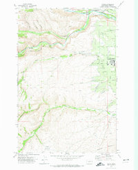
1971 Map of Tieton
USGS Topo · Published 1974About this map
Tieton and the surrounding Yakima County landscape reveal a sophisticated water management system in the early 1970s. The agricultural character of the region is defined by an intricate network of irrigation features, including the Wapatox Canal, Main Canal, and Old Naches Canal, which draw from the Naches River. To the west, the terrain rises sharply toward Bethel Ridge and Cowiche Mountain, where the Oak Creek Wildlife Recreation Area Headquarters sits near the confluence of Oak Creek and the river. Numerous named canyons such as McDaniel Canyon and French Canyon carve through the uplands, while the flatter eastern sections are marked by family-named roads like Dilley Road and Webert Road. A Landing Strip and various siphons and aqueducts further illustrate the infrastructure required to sustain this high-desert community.
Find a feature on this map
42 named features on this map. Tap any name to fly to it.
Don’t see what you’re looking for? This feature index may not catch every label — zoom into the map to look around manually.
Map Details
Editions of this 1971 Tieton Map
2 editions found
Other maps of this area

1899 · Ellensburg
USGS Topo · 1:125,000

1901 · Ellensburg
USGS Topo · 1:125,000

1950 · Yakima
USGS Topo · 1:250,000

1958 · Ellensburg
USGS Topo · 1:62,500

1958 · Wiley City
USGS Topo · 1:24,000

1958 · Naches
USGS Topo · 1:24,000

1958 · Yakima
USGS Topo · 1:250,000

1961 · Yakima
USGS Topo · 1:250,000

1971 · Nile
USGS Topo · 1:24,000
1971 · Milk Canyon
USGS Topo · 1:24,000