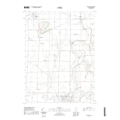
2019 Map of Tiffin North
USGS Topo · Published 2019About this map
Tiffin and the winding course of the Sandusky River dominate this landscape in north-central Ohio. The river forms a central corridor for the region, featuring prominent landmarks like Abbotts Island and historic crossings at Abbotts Bridge and the Fort Seneca Bridge. The settlement pattern reflects the agricultural and civic growth of Seneca County, with the northern reaches of the county seat connected to smaller outlying communities such as Fort Seneca, Old Fort, and Bettsville.
Find a feature on this map
73 named features on this map. Tap any name to fly to it.
Don’t see what you’re looking for? This feature index may not catch every label — zoom into the map to look around manually.
Map Details
Editions of this 2019 Tiffin North Map
This is the sole edition of this map. No revisions or reprints were ever made.
Other maps of this area

1901 · Fostoria
USGS Topo · 1:62,500

1901 · Fremont
USGS Topo · 1:62,500

1901 · Elmore
USGS Topo · 1:62,500

1903 · Fremont
USGS Topo · 1:62,500

1903 · Fostoria
USGS Topo · 1:62,500

1903 · Elmore
USGS Topo · 1:62,500

1906 · Tiffin
USGS Topo · 1:62,500

1956 · Toledo
USGS Topo · 1:250,000

1958 · Fremont West
USGS Topo · 1:24,000
1958 · Fremont East
USGS Topo · 1:24,000