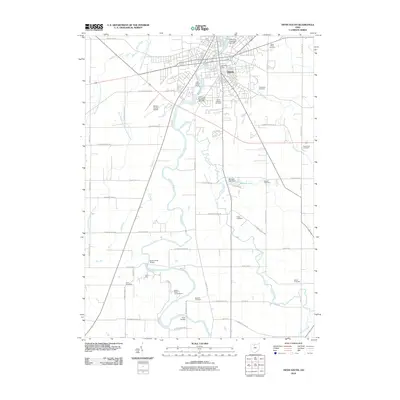
2010 Map of Tiffin South
USGS Topo · Published 2010About this map
The Sandusky River winds southward from the industrial and residential core of Tiffin, defining the corridor between the city and the agricultural lands of Seneca County. In this 2010 edition, the urban landscape is well-developed, featuring key infrastructure such as the Tiffin Post Office and the Tiffin Water Works, alongside several low-head dams like Tiffin Low Head Dam 1031-007. For genealogists, the map is remarkably dense with burial grounds, ranging from the large Greenlawn Cemetery and Saint Josephs Cemetery near the city center to smaller rural plots like Randall Cemetery and Shock Cemetery.
Find a feature on this map
69 named features on this map. Tap any name to fly to it.
Don’t see what you’re looking for? This feature index may not catch every label — zoom into the map to look around manually.
Map Details
Editions of this 2010 Tiffin South Map
This is the sole edition of this map. No revisions or reprints were ever made.
Other maps of this area

1901 · Fostoria
USGS Topo · 1:62,500

1903 · Fostoria
USGS Topo · 1:62,500

1906 · Sycamore
USGS Topo · 1:62,500

1906 · Tiffin
USGS Topo · 1:62,500

1907 · Upper Sandusky
USGS Topo · 1:62,500

1950 · Marion
USGS Topo · 1:250,000

1956 · Toledo
USGS Topo · 1:250,000

1960 · Sycamore
USGS Topo · 1:24,000
1960 · Watson
USGS Topo · 1:24,000

1960 · Tiffin South
USGS Topo · 1:24,000