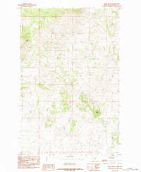
1984 Map of Tiger Butte
USGS Topo · Published 1984About this map
Tiger Butte dominates the southern landscape of this Chouteau County terrain, where the Missouri River breaks topography begins to transition into more pronounced highlands. This 1984 provisional survey highlights the intricate drainage systems that define the area, including the southward-flowing Little Birch Creek and the winding course of Dog Creek. The map serves as a detailed record of the natural landforms that dictated early ranching and travel routes in this part of Montana, showcasing prominent elevations like Sawmill Butte and the elongated spine of Pecora Ridge.
Find a feature on this map
9 named features on this map. Tap any name to fly to it.
Don’t see what you’re looking for? This feature index may not catch every label — zoom into the map to look around manually.
Map Details
Editions of this 1984 Tiger Butte Map
This is the sole edition of this map. No revisions or reprints were ever made.
Other maps of this area

1953 · Havre
USGS Topo · 1:250,000

1954 · Lewistown
USGS Topo · 1:250,000

1957 · Havre
USGS Topo · 1:250,000

1958 · Havre
USGS Topo · 1:250,000

1959 · Lewistown
USGS Topo · 1:250,000

1959 · Warrick
USGS Topo · 1:62,500

1959 · Centennial Mountain
USGS Topo · 1:62,500
1984 · Eskay NE
USGS Topo · 1:24,000

1984 · Big John Butte
USGS Topo · 1:24,000
1984 · Warrick
USGS Topo · 1:24,000