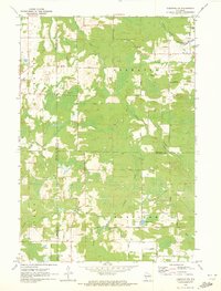
1970 Map of Tigerton NW
USGS Topo · Published 1973About this map
The South Branch Embarrass River and Comet Creek dominate the drainage patterns of this 1970 snapshot of north-central Wisconsin, where the borders of Shawano, Waupaca, Marathon, and Portage counties converge. The small settlement of Norske serves as a local waypoint, connected by a network of rural routes such as Norske Road and Nerdahl Road. The landscape is a complex mix of wooded terrain and wetlands, particularly evident within the town of Germania and the southern area of Harrison.
Find a feature on this map
32 named features on this map. Tap any name to fly to it.
Don’t see what you’re looking for? This feature index may not catch every label — zoom into the map to look around manually.
Map Details
Editions of this 1970 Tigerton NW Map
2 editions found
Other maps of this area

1899 · Wausau
USGS Topo · 1:125,000

1902 · Wausau
USGS Topo · 1:125,000

1953 · Hatley
USGS Topo · 1:48,000

1954 · Wittenberg
USGS Topo · 1:48,000

1955 · Tigerton
USGS Topo · 1:48,000

1955 · Rosholt
USGS Topo · 1:48,000

1955 · Green Bay
USGS Topo · 1:250,000

1964 · Wittenberg
USGS Topo · 1:62,500

1964 · Hatley
USGS Topo · 1:62,500

1969 · Rosholt
USGS Topo · 1:24,000