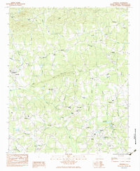
1983 Map of Tigerville
USGS Topo · Published 1983About this map
Tigerville and the campus of North Greenville Jr College anchor this topographic study of the South Carolina foothills in the early 1980s. The landscape is defined by the branching waters of the Middle Tyger River and the South Tyger River, which weave through the terrain between prominent heights like Pax Mountain and Glassy Mtn. Small communities and crossroad settlements such as Highland, Skyland, and O'Neal are scattered throughout, each marked by local landmarks like Berrys Millpond and the State Fish Hatchery. The map reveals a deeply rooted rural infrastructure, with numerous country churches and associated grounds, including Fews Chapel Cem and St Pauls Ch Cem. Aviation footprints are visible at the Wilbanks Airport and O'Neal Airport, while the hydrology of the area is highlighted by features like Sudduth Pond and Edwards Lake.
Find a feature on this map
50 named features on this map. Tap any name to fly to it.
Don’t see what you’re looking for? This feature index may not catch every label — zoom into the map to look around manually.
Map Details
Editions of this 1983 Tigerville Map
2 editions found
Other maps of this area

1907 · Saluda
USGS Topo · 1:125,000

1935 · Greer
USGS Topo · 1:48,000

1935 · Greenville
USGS Topo · 1:48,000

1935 · Zirconia
USGS Topo · 1:24,000

1938 · Greenville
USGS Topo · 1:62,500

1938 · Greer
USGS Topo · 1:62,500

1946 · Zirconia
USGS Topo · 1:24,000
1947 · Zirconia
USGS Topo · 1:24,000
1954 · Zirconia
USGS Topo · 1:25,000

1954 · Greenville
USGS Topo · 1:250,000