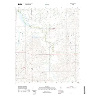
2018 Map of Tilden
USGS Topo · Published 2018About this map
Pine Barren Creek and its many winding tributaries dominate this landscape on the border of Dallas and Wilcox counties. Near the Alabama River, prominent elevations like Hurricane Bluff and Sakti Hata overlook the riverbank, while the interior is defined by a series of small, scattered cemeteries that speak to the long-standing rural community structure. Researchers can identify Boykin Cem, Butler Cem, Campbell Cem, and the dual sites of Older Hill Cem and Society Hill Cem. The settlement of Tilden serves as a local anchor along Co Rd 412. The presence of Dawson Lndg and Saint John Bar along the river highlights a history of river-based navigation and transport that has historically shaped this part of the Alabama Black Belt.
Find a feature on this map
32 named features on this map. Tap any name to fly to it.
Don’t see what you’re looking for? This feature index may not catch every label — zoom into the map to look around manually.
Map Details
Editions of this 2018 Tilden Map
This is the sole edition of this map. No revisions or reprints were ever made.
Other maps of this area
1953 · Montgomery
USGS Topo · 1:250,000
1953 · Andalusia
USGS Topo · 1:250,000
1956 · Montgomery
USGS Topo · 1:250,000
1957 · Montgomery
USGS Topo · 1:250,000
1957 · Andalusia
USGS Topo · 1:250,000
1957 · Carlowville
USGS Topo · 1:62,500
1973 · Camden South
USGS Topo · 1:24,000
1974 · Crumptonia
USGS Topo · 1:24,000
1974 · Camden North
USGS Topo · 1:24,000
1975 · Carlowville NE
USGS Topo · 1:24,000