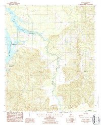
1987 Map of Tilden
USGS Topo · Published 1987About this map
Pine Barren Creek meanders through the central landscape of this 1980s survey, marking the transition between the rolling uplands of Tilden and the low-lying waters of the Alabama River. The map captures a moment in the local economy and recreation following the development of the William "Bill" Dannelly Reservoir, which dominates the northwestern corner. The boundary between Dallas and Wilcox counties cuts across the creek, illustrating the rural character of the region. Local industry is evidenced by the presence of a Clay Pit and Gravel Pit, while the establishment of Roland Cooper State Park and a prominent Boat Ramp suggests the area's significance for regional water-based activities and public land use.
Find a feature on this map
9 named features on this map. Tap any name to fly to it.
Don’t see what you’re looking for? This feature index may not catch every label — zoom into the map to look around manually.
Map Details
Editions of this 1987 Tilden Map
This is the sole edition of this map. No revisions or reprints were ever made.
Other maps of this area

1953 · Montgomery
USGS Topo · 1:250,000

1953 · Andalusia
USGS Topo · 1:250,000

1956 · Montgomery
USGS Topo · 1:250,000

1957 · Montgomery
USGS Topo · 1:250,000

1957 · Andalusia
USGS Topo · 1:250,000

1957 · Carlowville
USGS Topo · 1:62,500

1973 · Camden South
USGS Topo · 1:24,000

1974 · Crumptonia
USGS Topo · 1:24,000
1974 · Camden North
USGS Topo · 1:24,000

1975 · Carlowville NE
USGS Topo · 1:24,000