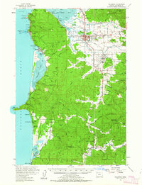
1955 Map of Tillamook
USGS Topo · Published 1963About this map
Tillamook serves as the focal point of this coastal survey, where the Wilson River, Trask River, and Tillamook River converge into the expansive Tillamook Bay. The mid-century landscape is defined by its dairy and maritime industries, notably marked by the Cheese Factory and the extensive network of sloughs like Hoquarten Slough that facilitated transport through the lowlands. Along the rugged Pacific coastline, the Cape Meares Lighthouse stands above the cliffs of Cape Meares State Park, while further south, the secluded Netarts Bay and Sand Lake dominate the shoreline topography.
Find a feature on this map
92 named features on this map. Tap any name to fly to it.
Don’t see what you’re looking for? This feature index may not catch every label — zoom into the map to look around manually.
Map Details
Editions of this 1955 Tillamook Map
3 editions found

Other maps of this area

1937 · Nehalem
USGS Topo · 1:62,500

1937 · Enright
USGS Topo · 1:62,500

1941 · Nestucca Bay
USGS Topo · 1:62,500

1941 · Enright
USGS Topo · 1:62,500

1942 · Ginger Peak
USGS Topo · 1:62,500

1942 · Spirit Mtn
USGS Topo · 1:62,500

1942 · Nestucca Bay
USGS Topo · 1:62,500

1942 · Tillamook
USGS Topo · 1:62,500

1943 · Nehalem
USGS Topo · 1:62,500

1948 · Vancouver
USGS Topo · 1:250,000