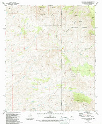
1986 Map of Tillie Hall Peak
USGS Topo · Published 1987About this map
The Apache National Forest and Gila National Forest converge at the Arizona-New Mexico border, where high-desert drainages and mountain summits define the geography. This region is dominated by prominent landmarks such as Tillie Hall Peak, Yellowjacket Peak, and the Summit Mountains to the south. The complex system of washes and canyons, including Hells Hole Canyon, Bitter Creek, and Iron Canyon, suggests a landscape shaped by intermittent water and steep relief. Scattered throughout the terrain are several small-scale resource extractions labeled simply as Mine and Prospect, concentrated particularly near Twin Peaks and along the southern mountain slopes. A single Corral provides evidence of ranching activity in an otherwise uninhabited reach of the borderlands, while the boundary between Greenlee and Grant counties bisects the southern half of the quadrangle.
Find a feature on this map
30 named features on this map. Tap any name to fly to it.
Don’t see what you’re looking for? This feature index may not catch every label — zoom into the map to look around manually.
Map Details
Editions of this 1986 Tillie Hall Peak Map
This is the sole edition of this map. No revisions or reprints were ever made.
Other maps of this area

1910 · Mogollon
USGS Topo · 1:125,000

1912 · Mogollon
USGS Topo · 1:125,000

1913 · Morenci
USGS Topo · 1:125,000

1915 · Morenci
USGS Topo · 1:125,000

1954 · Silver City
USGS Topo · 1:250,000

1954 · Clifton
USGS Topo · 1:250,000

1957 · Clifton
USGS Topo · 1:250,000

1958 · Silver City
USGS Topo · 1:250,000

1958 · Clifton
USGS Topo · 1:250,000

1959 · Steeple Rock
USGS Topo · 1:62,500