
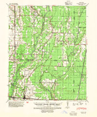
1940 Map of Tilton
USGS Topo · Published 1947About this map
The Cache RIVER and Bayou De View meander through this landscape on the eve of World War II, defining the borderlands where Jackson, Woodruff, Cross, and Poinsett Counties meet. The area is heavily defined by its transit networks, anchored by the Missouri Pacific and Chicago Rock Island and Pacific railroads. Larger settlements like McCrory and Patterson serve as regional hubs, while a dense network of country schools such as Citizenship Sch and Pumpkin Bend Sch suggest a robust rural population during this era. Numerous family-named landmarks and spiritual centers, including Fakes Chapel & Cem and Mt Zion Ch & Cem, provide specific points of interest for genealogists tracking local lineages. The mapping also details early state roads like Ark 17 and Ark 64, alongside smaller industrial features like Wrapes Spur.
Find a feature on this map
95 named features on this map. Tap any name to fly to it.
Don’t see what you’re looking for? This feature index may not catch every label — zoom into the map to look around manually.
Map Details
Editions of this 1940 Tilton Map
2 editions found
Other maps of this area

1935 · Newport
USGS Topo · 1:62,500

1935 · Augusta
USGS Topo · 1:62,500

1935 · Tuckerman
USGS Topo · 1:62,500

1935 · Gregory
USGS Topo · 1:62,500

1939 · Vanndale
USGS Topo · 1:62,500

1939 · Weiner
USGS Topo · 1:62,500

1939 · Wynne
USGS Topo · 1:62,500

1939 · Hunter
USGS Topo · 1:62,500

1953 · Memphis
USGS Topo · 1:250,000

1956 · Memphis
USGS Topo · 1:250,000