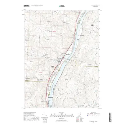
2019 Map of Tiltonsville
USGS Topo · Published 2019About this map
The Ohio River corridor north of Wheeling serves as a critical boundary between the industrial and residential landscapes of eastern Ohio and the Northern Panhandle of West Virginia. This 2019 survey documents a dense network of riverside communities, from the larger hubs of Martins Ferry and Tiltonsville to smaller hillside settlements like Yorkville and Rayland. The geography is defined by a series of hollows and ridges, such as Limestone Hollow and Chestnut Ridge, which dictate the placement of local infrastructure and older family sites. Genealogists will find a wealth of specific data points, including several smaller burial grounds like the Everson Family Cem and Bayless Private Cem. The map also captures modern land use, including the Wheeling Ohio County Airport and the conversion of former industrial corridors into recreational assets like the Brooke Pioneer Rail-Trail.
Find a feature on this map
80 named features on this map. Tap any name to fly to it.
Don’t see what you’re looking for? This feature index may not catch every label — zoom into the map to look around manually.
Map Details
Editions of this 2019 Tiltonsville Map
This is the sole edition of this map. No revisions or reprints were ever made.
Other maps of this area

1901 · Cadiz
USGS Topo · 1:62,500

1902 · Wheeling
USGS Topo · 1:62,500

1903 · Cadiz
USGS Topo · 1:62,500

1904 · Steubenville
USGS Topo · 1:62,500

1905 · St. Clairsville
USGS Topo · 1:62,500

1935 · Wheeling
USGS Topo · 1:62,500

1935 · Steubenville
USGS Topo · 1:62,500

1942 · Wheeling
USGS Topo · 1:62,500

1942 · Steubenville
USGS Topo · 1:62,500

1951 · Canton
USGS Topo · 1:250,000