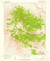
1961 Map of Timber Mountain
USGS Topo · Published 1962About this map
Nellis Air Force Range and the Nevada Test Site Area 18 define this landscape during a pivotal era of American nuclear and military research. Mapped in cooperation with the Atomic Energy Commission just after the 1950s, the terrain is dominated by the volcanic massif of Timber Mountain. The complex topography includes high-altitude survey markers like Vabm Timber 7422 and deep drainage systems such as Fortymile Canyon. Beyond the prominent heights, the map details the rudimentary infrastructure required to navigate this restricted desert environment, featuring the Cat Canyon Road and various Jeep Trail routes. A single Spring provides a rare point of natural water near the mountain's western slopes, while the eastern edge is marked by the flat expanse of Buckboard Mesa. The combination of geological surveying and military zoning illustrates the mid-century transformation of the Great Basin into a high-security federal testing ground.
Find a feature on this map
11 named features on this map. Tap any name to fly to it.
Don’t see what you’re looking for? This feature index may not catch every label — zoom into the map to look around manually.
Map Details
Editions of this 1961 Timber Mountain Map
3 editions found
Other maps of this area

1908 · Kawich
USGS Topo · 1:250,000

1908 · Furnace Creek
USGS Topo · 1:250,000

1910 · Furnace Creek
USGS Topo · 1:250,000

1942 · Tolicha Peak
USGS Topo · 1:125,000

1942 · Wheelbarrow Peak
USGS Topo · 1:125,000

1942 · Skull Mountain
USGS Topo · 1:125,000

1942 · Bullfrog
USGS Topo · 1:125,000

1948 · Death Valley
USGS Topo · 1:250,000

1952 · Topopah Spring
USGS Topo · 1:62,500

1952 · Timber Mountain
USGS Topo · 1:62,500