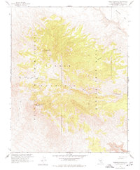
1961 Map of Timber Mountain
USGS Topo · Published 1977About this map
Nellis Air Force Range and the Nevada Test Site intersect across this high-desert terrain, reflecting a pivotal era of Cold War military activity in Nye County. The landscape is dominated by the massive dome of Timber Mountain, with its twin summits at North Timber Peak 7422 and South Timber Peak 7239 overlooking a complex network of dry drainage systems. In cooperation with the Atomic Energy Commission, this survey records the early infrastructure of the testing grounds, including several Jeep Trails and unnamed roads that snake through the canyons.
Find a feature on this map
15 named features on this map. Tap any name to fly to it.
Don’t see what you’re looking for? This feature index may not catch every label — zoom into the map to look around manually.
Map Details
Editions of this 1961 Timber Mountain Map
3 editions found
Other maps of this area

1908 · Kawich
USGS Topo · 1:250,000

1908 · Furnace Creek
USGS Topo · 1:250,000

1910 · Furnace Creek
USGS Topo · 1:250,000

1942 · Tolicha Peak
USGS Topo · 1:125,000

1942 · Wheelbarrow Peak
USGS Topo · 1:125,000

1942 · Skull Mountain
USGS Topo · 1:125,000

1942 · Bullfrog
USGS Topo · 1:125,000

1948 · Death Valley
USGS Topo · 1:250,000

1952 · Topopah Spring
USGS Topo · 1:62,500

1952 · Timber Mountain
USGS Topo · 1:62,500