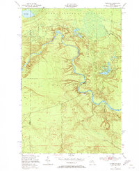
1951 Map of Timberlost
USGS Topo · Published 1973About this map
The Tahquamenon River snakes through the heart of this Upper Peninsula landscape, marking the transition between the Lake Superior State Forest and the diverse wetlands of Whitefish. This area, mapped in the early 1950s, highlights the proximity of the Tahquamenon Falls State Park and the famous Lower Falls. The settlement pattern reflects a remote, resource-driven geography, with small outposts like Timberlost and Whitehouse Landing situated along the river's path.
Find a feature on this map
18 named features on this map. Tap any name to fly to it.
Don’t see what you’re looking for? This feature index may not catch every label — zoom into the map to look around manually.
Map Details
Editions of this 1951 Timberlost Map
4 editions found
Other maps of this area

1951 · Shelldrake
USGS Topo · 1:24,000

1951 · Sheephead Lake
USGS Topo · 1:24,000

1951 · Emerson
USGS Topo · 1:24,000

1951 · Piatt Lake
USGS Topo · 1:24,000

1951 · Big Beaver Creek
USGS Topo · 1:24,000

1951 · Timberlost
USGS Topo · 1:24,000

1951 · Eckerman
USGS Topo · 1:62,500

1951 · Shelldrake
USGS Topo · 1:62,500

1954 · Sault Sainte Marie
USGS Topo · 1:250,000

1956 · Sault Sainte Marie
USGS Topo · 1:250,000