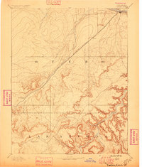
1894 Map of Timpas
USGS Topo · Published 1896About this map
La Junta stands as the primary hub in this late 19th-century landscape, positioned where the Arkansas River meets the heavy infrastructure of the Atchison Topeka and Santa Fe Railroad. The survey reveals a region defined by the transition from high plains to deeply eroded canyonlands, particularly as the Purgatoire River carves through the southern portion of the map. This area is a significant corridor of movement, showing the proximity of the established Santa Fe Trail to the modern rail lines of the era.
Find a feature on this map
28 named features on this map. Tap any name to fly to it.
Don’t see what you’re looking for? This feature index may not catch every label — zoom into the map to look around manually.
Map Details
Editions of this 1894 Timpas Map
5 editions found

Other maps of this area

1891 · Catlin
USGS Topo · 1:125,000

1891 · Higbee
USGS Topo · 1:125,000

1891 · Las Animas
USGS Topo · 1:125,000

1891 · Timpas
USGS Topo · 1:125,000

1891 · Nepesta
USGS Topo · 1:125,000

1891 · Apishapa
USGS Topo · 1:125,000

1891 · Mesa De Maya
USGS Topo · 1:125,000

1892 · Elmoro
USGS Topo · 1:125,000

1892 · Mt Carrizo
USGS Topo · 1:125,000

1893 · Higbee
USGS Topo · 1:125,000