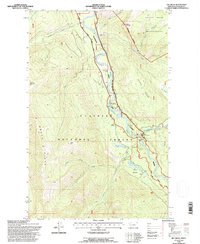
1994 Map of Tin Creek
USGS Topo · Published 1997About this map
South Fork Flathead River serves as the central artery for this backcountry landscape within the Flathead National Forest. This 1994 revision captures a remote interior of northwestern Montana, anchored by the small settlement of Spotted Bear and its adjacent Spotted Bear Landing Field. The map illustrates a transition from the managed timberlands of the national forest to the protected wilderness, notably where the Wilderness Boundary marks the edge of the Great Bear Wilderness.
Find a feature on this map
31 named features on this map. Tap any name to fly to it.
Don’t see what you’re looking for? This feature index may not catch every label — zoom into the map to look around manually.
Map Details
Editions of this 1994 Tin Creek Map
This is the sole edition of this map. No revisions or reprints were ever made.
Other maps of this area

1913 · Marias Pass
USGS Topo · 1:125,000

1914 · Nyack
USGS Topo · 1:125,000

1936 · Silvertip
USGS Topo · 1:96,000

1942 · Silvertip
USGS Topo · 1:125,000

1955 · Choteau
USGS Topo · 1:250,000

1957 · Choteau
USGS Topo · 1:250,000

1958 · Choteau
USGS Topo · 1:250,000

1958 · Circus Peak
USGS Topo · 1:24,000

1958 · Quintonkon
USGS Topo · 1:24,000

1958 · Horseshoe Peak
USGS Topo · 1:24,000