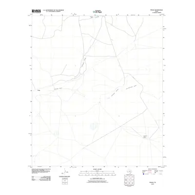
2010 Map of Tinaja
USGS Topo · Published 2010About this map
Tinaja sits at the heart of this Presidio County landscape, where the High Plains of West Texas are defined by an intricate network of drainage channels. The area is characterized by these intermittent waterways, such as the convergence of Chambers Draw and Antelope Draw, which dictate the local topography and historical movement across the range. Infrastructure in this remote stretch of the Trans-Pecos is sparse, consisting primarily of private ranching facilities and long-distance connectors. The Nopal Rd traverses the northern section of the map, while the Alta Vista Ranch Airport in the southeast corner provides a critical link for aerial access to this expansive ranching country. Other notable watercourses including Joe Williams Draw, Colquitt Draw, and Long Draw further illustrate the watershed patterns essential to life and livestock in this arid environment.
Find a feature on this map
8 named features on this map. Tap any name to fly to it.
Don’t see what you’re looking for? This feature index may not catch every label — zoom into the map to look around manually.
Map Details
Editions of this 2010 Tinaja Map
This is the sole edition of this map. No revisions or reprints were ever made.
Other maps of this area

1895 · Marfa
USGS Topo · 1:125,000

1895 · Alpine
USGS Topo · 1:125,000

1954 · Fort Stockton
USGS Topo · 1:250,000

1958 · Fort Stockton
USGS Topo · 1:250,000

1959 · Marfa
USGS Topo · 1:250,000

1965 · Marfa
USGS Topo · 1:250,000

1972 · Paisano
USGS Topo · 1:24,000

1972 · Nopal
USGS Topo · 1:24,000

1973 · Fort Stockton
USGS Topo · 1:250,000
1983 · Cactus Flat
USGS Topo · 1:24,000