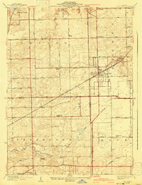
1929 Map of Tinley Park
USGS Topo · Published 1941About this map
Tinley Park and Orland Park anchor this detailed look at the southern Cook and northern Will County line during a period of steady transition from rural townships to established villages. The landscape is defined by the Old Indian Boundary slicing diagonally across the grid, a legacy of early frontier treaties. The regional transportation network is anchored by the Chicago and Rock Island Pacific and the Wabash Railroad, which supported the agrarian economy while connecting these growing settlements to the larger Chicago metro area.
Find a feature on this map
38 named features on this map. Tap any name to fly to it.
Don’t see what you’re looking for? This feature index may not catch every label — zoom into the map to look around manually.
Map Details
Editions of this 1929 Tinley Park Map
3 editions found

Other maps of this area

1890 · Des Plaines
USGS Topo · 1:62,500

1892 · Calumet
USGS Topo · 1:62,500

1893 · Calumet
USGS Topo · 1:62,500

1894 · Des Plaines
USGS Topo · 1:62,500

1900 · Des Plaines
USGS Topo · 1:62,500

1900 · Calumet
USGS Topo · 1:62,500

1901 · Calumet
USGS Topo · 1:62,500

1901 · Des Plaines
USGS Topo · 1:62,500

1928 · Palos Park
USGS Topo · 1:24,000

1928 · Sag Bridge
USGS Topo · 1:24,000