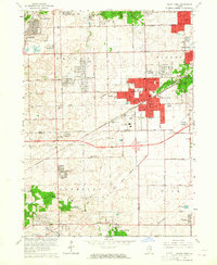
1963 Map of Tinley Park
USGS Topo · Published 1964About this map
Tinley Park and the surrounding Cook and Will County borderlands show a landscape in the midst of mid-century suburban expansion. The concentrated development of the village is balanced by the sprawling grounds of the Tinley Park State Hospital and the forested corridors of the Forest Preserve, including Yankee Woods. Industrial and utility markers of the era are evident, such as the Radio Tower (WLS-WENR) and the Chicago Rock Island and Pacific railroad, which historically anchored the region's transport.
Find a feature on this map
61 named features on this map. Tap any name to fly to it.
Don’t see what you’re looking for? This feature index may not catch every label — zoom into the map to look around manually.
Map Details
Editions of this 1963 Tinley Park Map
4 editions found
Other maps of this area

1890 · Des Plaines
USGS Topo · 1:62,500

1892 · Calumet
USGS Topo · 1:62,500

1893 · Calumet
USGS Topo · 1:62,500

1894 · Des Plaines
USGS Topo · 1:62,500

1900 · Des Plaines
USGS Topo · 1:62,500

1900 · Calumet
USGS Topo · 1:62,500

1901 · Calumet
USGS Topo · 1:62,500

1901 · Des Plaines
USGS Topo · 1:62,500

1928 · Palos Park
USGS Topo · 1:24,000

1928 · Sag Bridge
USGS Topo · 1:24,000