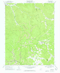
1966 Map of Tioga
USGS Topo · Published 1966About this map
Tioga serves as a central hub for the coal and timber country of Nicholas County in the mid-1960s, where the Baltimore and Ohio railroad corridor follows the winding path of Strouds Creek. This landscape is defined by its industrial activity, featuring numerous Strip Mines, a Tipple, and several Tailings Ponds concentrated around the Beaver and Hamilton districts. The map documents the persistent rural character of the area through family-named landmarks and institutions like the Walnut Grove Chapel, Rader Chapel, and the Walnut schoolhouse.
Find a feature on this map
78 named features on this map. Tap any name to fly to it.
Don’t see what you’re looking for? This feature index may not catch every label — zoom into the map to look around manually.
Map Details
Editions of this 1966 Tioga Map
3 editions found
Other maps of this area

1889 · Nicholas
USGS Topo · 1:125,000

1891 · Nicholas
USGS Topo · 1:125,000

1893 · Sutton
USGS Topo · 1:125,000

1901 · Nicholas
USGS Topo · 1:125,000

1908 · Gassaway
USGS Topo · 1:48,000

1908 · Sutton
USGS Topo · 1:48,000

1910 · Sutton Special
USGS Topo · 1:62,500

1910 · Gassaway
USGS Topo · 1:62,500

1913 · Summersville
USGS Topo · 1:48,000

1915 · Cowen
USGS Topo · 1:48,000