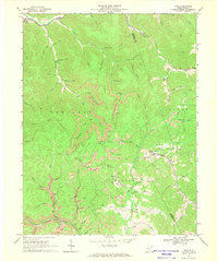
1966 Map of Tioga
USGS Topo · Published 1970About this map
Tioga serves as a focal point in this 1966 survey of the Nicholas Co and Webster Co border, where industrial resource extraction and rural settlement meet. The Baltimore and Ohio railroad corridor tracks through the eastern portion of the map, supporting a landscape marked by coal operations, including a Tipple, Tailings Pond, and several Strip Mine locations. The terrain is defined by a dense network of drainages such as Beaver Run, Strouds Creek, and the Birch River, which create the deep hollows characteristic of the region.
Find a feature on this map
68 named features on this map. Tap any name to fly to it.
Don’t see what you’re looking for? This feature index may not catch every label — zoom into the map to look around manually.
Map Details
Editions of this 1966 Tioga Map
3 editions found
Other maps of this area

1889 · Nicholas
USGS Topo · 1:125,000

1891 · Nicholas
USGS Topo · 1:125,000

1893 · Sutton
USGS Topo · 1:125,000

1901 · Nicholas
USGS Topo · 1:125,000

1908 · Gassaway
USGS Topo · 1:48,000

1908 · Sutton
USGS Topo · 1:48,000

1910 · Sutton Special
USGS Topo · 1:62,500

1910 · Gassaway
USGS Topo · 1:62,500

1913 · Summersville
USGS Topo · 1:48,000

1915 · Cowen
USGS Topo · 1:48,000