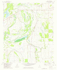
1981 Map of Tippo
USGS Topo · Published 1982About this map
The Tallahatchie River and its intricate network of associated bayous and lakes define this alluvial landscape in the early 1980s. This survey illustrates a rural environment where life centers on small communities like Tippo and Effie, and a high concentration of country churches serves the local population. Significant spiritual landmarks include Locopolis Ch, Cowart Ch, and Morning Star Ch, many of which sit near named water bodies such as Alligator Lake and Otter Lake. The map details the transition from traditional river-bound transport to more modern infrastructure, noting the Old Railroad Grade and Brown Landing Field. Large land holdings like Rabbit Ridge Plantation persist alongside educational and civic sites such as Strider Academy and a Community Center, reflecting the social fabric of the Mississippi Delta during this period.
Find a feature on this map
42 named features on this map. Tap any name to fly to it.
Don’t see what you’re looking for? This feature index may not catch every label — zoom into the map to look around manually.
Map Details
Editions of this 1981 Tippo Map
This is the sole edition of this map. No revisions or reprints were ever made.
Other maps of this area

1931 · Sumner
USGS Topo · 1:48,000

1932 · Philipp
USGS Topo · 1:48,000

1932 · Tutwiler
USGS Topo · 1:48,000

1935 · Crowder
USGS Topo · 1:62,500

1935 · Sumner
USGS Topo · 1:62,500

1935 · Tutwiler
USGS Topo · 1:62,500

1935 · Philipp
USGS Topo · 1:62,500

1939 · Sumner
USGS Topo · 1:62,500

1939 · Crowder
USGS Topo · 1:62,500

1939 · Philipp
USGS Topo · 1:62,500