
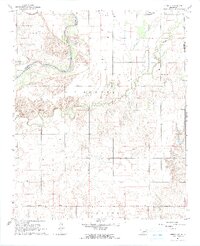
1964 Map of Tipton SE
USGS Topo · Published 1965About this map
The confluence of the Red River and the North Fork Red River defines the landscape of this southwestern Oklahoma corner, where the borders of Jackson and Tillman counties meet. This 1964 survey reveals a rural landscape organized by the Base Line and a network of section-line roads, anchored by small community nodes. In the north, the St Louis San Francisco railroad cuts across the territory near the Pleasant Valley Ch and the adjacent Pleasant Valley Community Hall. This area, likely dependent on groundwater as evidenced by numerous mapped wells, also features a Pleasant Valley Landing Strip. To the south, the Center View Cem and Mt Gillian Ch provide essential touchstones for local family history, while the winding course of Otter Creek shapes the eastern boundary of the Hunter township.
Find a feature on this map
17 named features on this map. Tap any name to fly to it.
Don’t see what you’re looking for? This feature index may not catch every label — zoom into the map to look around manually.
Map Details
Editions of this 1964 Tipton SE Map
2 editions found
Other maps of this area

1950 · Snyder
USGS Topo · 1:62,500

1955 · Lawton
USGS Topo · 1:250,000

1956 · Manitou
USGS Topo · 1:24,000

1956 · Snyder
USGS Topo · 1:24,000

1956 · Snyder
USGS Topo · 1:62,500

1958 · Frederick
USGS Topo · 1:62,500

1964 · Tipton
USGS Topo · 1:24,000

1964 · Headrick
USGS Topo · 1:24,000

1964 · Long Mountain
USGS Topo · 1:24,000

1974 · Hollister NW
USGS Topo · 1:24,000