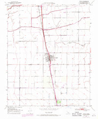
1950 Map of Tipton
USGS Topo · Published 1971About this map
Tipton serves as the central hub of this agricultural landscape in California's Central Valley, positioned directly along the Southern Pacific railroad line. The settlement pattern is defined by a rigid grid of rural roads like Oakland Road and Poplar Ave, supporting the expansive irrigation and drainage network necessary for valley farming. Water management is a dominant theme, evidenced by the presence of Elk Bayou, Mitchell Slough, and the branching forks of the Tule River. Just west of the town center, the Tipton Cem provides a focal point for local genealogical interest. To the south, the small siding of Quail sits along the tracks, reflecting the era's reliance on rail transport for moving agricultural goods. The map also identifies industrial sites like a Gravel Pit, indicating the local extraction of materials for the valley's infrastructure development during the mid-20th century.
Find a feature on this map
19 named features on this map. Tap any name to fly to it.
Don’t see what you’re looking for? This feature index may not catch every label — zoom into the map to look around manually.
Map Details
Editions of this 1950 Tipton Map
2 editions found
Other maps of this area

1925 · Tulare
USGS Topo · 1:31,680

1925 · Tipton
USGS Topo · 1:31,680

1927 · Cairns Corner
USGS Topo · 1:31,680

1927 · Lake View School
USGS Topo · 1:31,680

1927 · Paige
USGS Topo · 1:31,680

1927 · Tulare
USGS Topo · 1:31,680

1928 · Tipton
USGS Topo · 1:31,680

1928 · Woodville
USGS Topo · 1:31,680

1929 · Alpaugh
USGS Topo · 1:31,680

1929 · Sausalito School
USGS Topo · 1:31,680