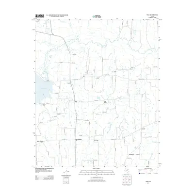
2013 Map of Tira
USGS Topo · Published 2013About this map
S Sulphur River meanders across the northern reaches of this north Texas landscape, defining a network of seasonal creeks and sloughs that feed into the large expanse of Cooper Lake to the west. This territory in northern Hopkins County is characterized by a series of small, interconnected rural communities that speak to the area's agricultural roots. The map documents the relationship between established hamlets like Birthright and New Birthright, as well as several family-named burial grounds including Aiguier Cem, Selt Cem, and Rushing Cem. Local aviation is represented by Chuckster Airport, situated between Tira and Oak Grove. The road system, dominated by routes like Farm Road 1536 and Farm Road 71 W, links these scattered settlements, while waterways such as Vaden Cr and Logston Br drain the gently undulating terrain toward the river basin.
Find a feature on this map
35 named features on this map. Tap any name to fly to it.
Don’t see what you’re looking for? This feature index may not catch every label — zoom into the map to look around manually.
Map Details
Editions of this 2013 Tira Map
This is the sole edition of this map. No revisions or reprints were ever made.
Other maps of this area

1953 · Texarkana
USGS Topo · 1:250,000

1956 · Texarkana
USGS Topo · 1:250,000

1962 · Sulphur Bluff
USGS Topo · 1:24,000

1963 · Minter
USGS Topo · 1:24,000

1964 · Sulphur Springs
USGS Topo · 1:24,000

1964 · Gafford Chapel
USGS Topo · 1:24,000

1964 · Charleston
USGS Topo · 1:24,000

1964 · Tira
USGS Topo · 1:24,000

1964 · Cooper North
USGS Topo · 1:24,000
1964 · Cooper South
USGS Topo · 1:24,000