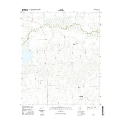
2016 Map of Tira
USGS Topo · Published 2016About this map
South Sulphur River meanders along the northern reaches of this rural landscape, defining the boundary between Delta and Hopkins Counties. The area is characterized by a high density of small rural settlements including Birthright, Tira, and Sandhill, connected by an intricate network of county roads and farm-to-market routes like FM 1536. Numerous family and community burial grounds, such as Aiguier Cem and Rushing Cem, are scattered throughout the countryside, offering significant points of interest for genealogical research in this part of East Texas. The terrain is marked by seasonal drainages like Acreage Slough and Wolf Cr, which feed into the primary river system. Near the center of the map, Chuckster Airport serves the small community of Tira, while further south, the crossroad hamlets of Shirley and Hatchetville illustrate the persistent small-scale settlement patterns of the region.
Find a feature on this map
72 named features on this map. Tap any name to fly to it.
Don’t see what you’re looking for? This feature index may not catch every label — zoom into the map to look around manually.
Map Details
Editions of this 2016 Tira Map
This is the sole edition of this map. No revisions or reprints were ever made.
Other maps of this area

1953 · Texarkana
USGS Topo · 1:250,000

1956 · Texarkana
USGS Topo · 1:250,000

1962 · Sulphur Bluff
USGS Topo · 1:24,000

1963 · Minter
USGS Topo · 1:24,000

1964 · Sulphur Springs
USGS Topo · 1:24,000

1964 · Gafford Chapel
USGS Topo · 1:24,000

1964 · Charleston
USGS Topo · 1:24,000

1964 · Tira
USGS Topo · 1:24,000

1964 · Cooper North
USGS Topo · 1:24,000
1964 · Cooper South
USGS Topo · 1:24,000