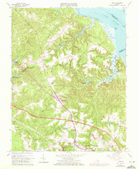
1965 Map of Toano
USGS Topo · Published 1972About this map
Toano and Norge serve as the primary hubs of activity along the Chesapeake and Ohio Railroad corridor in this mid-century survey of the Virginia Peninsula. The landscape is defined by the deep dissection of the coastal plain, where extensive wetland systems like Wahrani Swamp and Bird Swamp drain toward the York River and Ware Creek. This drainage pattern created natural sites for early industry, evidenced by Richardson Millpond and several unnamed mill ponds scattered throughout the tidal inlets.
Find a feature on this map
42 named features on this map. Tap any name to fly to it.
Don’t see what you’re looking for? This feature index may not catch every label — zoom into the map to look around manually.
Map Details
Editions of this 1965 Toano Map
4 editions found
Other maps of this area

1906 · Williamsburg
USGS Topo · 1:62,500

1917 · Urbanna
USGS Topo · 1:62,500

1917 · Toano
USGS Topo · 1:62,500

1918 · Toano
USGS Topo · 1:62,500

1919 · New Kent
USGS Topo · 1:62,500

1943 · Richmond
USGS Topo · 1:250,000

1949 · Shacklefords
USGS Topo · 1:24,000

1949 · New Kent
USGS Topo · 1:24,000

1949 · Richmond
USGS Topo · 1:250,000

1950 · West Point
USGS Topo · 1:24,000