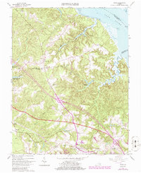
1965 Map of Toano
USGS Topo · Published 1986About this map
Toano and the surrounding James City County landscape are defined by a complex network of freshwater swamps and tidal waterways feeding into the York River. During this mid-1960s survey, the area maintained a rural character centered on crossroads settlements like Barhamsville and Norge. The Chesapeake and Ohio Railroad corridor serves as a primary axis for development, passing through the heart of Toano near historical landmarks like the Hickory Neck Ch. The topography reveals the transition from the upland ridges to the low-lying wetlands of Wahani Swamp and France Swamp. Notable infrastructure of the era includes the State Prison Camp No 16 in the northwest and the expansion of water resources at Diascund Creek Reservoir and Little Creek Reservoir, reflecting the region's evolving utility needs.
Find a feature on this map
42 named features on this map. Tap any name to fly to it.
Don’t see what you’re looking for? This feature index may not catch every label — zoom into the map to look around manually.
Map Details
Editions of this 1965 Toano Map
4 editions found
Other maps of this area

1906 · Williamsburg
USGS Topo · 1:62,500

1917 · Urbanna
USGS Topo · 1:62,500

1917 · Toano
USGS Topo · 1:62,500

1918 · Toano
USGS Topo · 1:62,500

1919 · New Kent
USGS Topo · 1:62,500

1943 · Richmond
USGS Topo · 1:250,000

1949 · Shacklefords
USGS Topo · 1:24,000

1949 · New Kent
USGS Topo · 1:24,000

1949 · Richmond
USGS Topo · 1:250,000

1950 · West Point
USGS Topo · 1:24,000