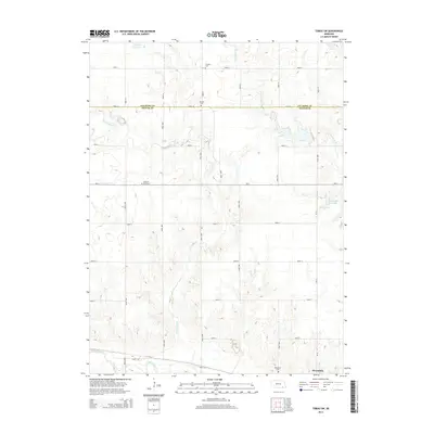
2014 Map of Tobias SW
USGS Topo · Published 2014About this map
The village of Alexandria anchors the southeastern corner of this rural landscape, situated just north of the Big Sandy Cr bottomlands. The terrain is defined by the convergence of several drainages, including Dry Sandy Cr, Little Sandy Cr, and Wolf Cr, which create a complex network of draws across the agricultural plains. This survey reveals a remarkably consistent pattern of section-line roads, such as Road AA and Road X, that straddle the boundary between Fillmore Co and Thayer Co. Scattered throughout these rural sections are small, established burial grounds including Antioch Cem, Pleasant Plain Cem, and Franklin Cem, which serve as quiet markers of the area's early settlement history. Water management is evident through the presence of the Sieber Reservoir and Kerwood Reservoir, providing essential resources for the surrounding farmsteads.
Find a feature on this map
34 named features on this map. Tap any name to fly to it.
Don’t see what you’re looking for? This feature index may not catch every label — zoom into the map to look around manually.
Map Details
Editions of this 2014 Tobias SW Map
This is the sole edition of this map. No revisions or reprints were ever made.
Other maps of this area
1898 · Hebron
USGS Topo · 1:125,000
1955 · Lincoln
USGS Topo · 1:250,000
1957 · Lincoln
USGS Topo · 1:250,000
1958 · Lincoln
USGS Topo · 1:250,000
1960 · Bruning
USGS Topo · 1:24,000
1960 · Tobias SW
USGS Topo · 1:24,000
1960 · Alexandria
USGS Topo · 1:24,000
1960 · Gladstone
USGS Topo · 1:24,000
1960 · Daykin
USGS Topo · 1:24,000
1960 · Hebron
USGS Topo · 1:24,000