
1967 Map of Tody School
USGS Topo · Published 1970About this map
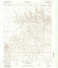
Atchison Topeka and Santa Fe railroad tracks cut across this Texas Panhandle landscape, following the winding course of Cowboy Creek through the rugged breaks of the eastern High Plains. The area is defined by the convergence of several drainages, including Sweetwater Creek and Graham Creek, which have carved deep relief into the terrain. In the late 1960s, the rural community life centered around Tody Sch, a small educational landmark located just north of the rail line. The landscape shows a mix of traditional ranching infrastructure and modern industrial utility, evidenced by a large Pipeline that bisects the southern portion of the quadrangle and scattered Gravel Pit operations. This survey captures the jurisdictional meeting point where Gray, Wheeler, Hemphill, and Roberts counties converge, illustrating how the natural topography dictated early transportation routes and settlement patterns in this part of Texas.
Find a feature on this map
10 named features on this map. Tap any name to fly to it.
Don’t see what you’re looking for? This feature index may not catch every label — zoom into the map to look around manually.
Map Details
Editions of this 1967 Tody School Map
2 editions found
Other maps of this area

1954 · Amarillo
USGS Topo · 1:250,000

1958 · Amarillo
USGS Topo · 1:250,000

1962 · Pond Creek
USGS Topo · 1:24,000

1962 · Spring Creek
USGS Topo · 1:24,000

1962 · Pond Creek NW
USGS Topo · 1:24,000

1963 · Mobeetie
USGS Topo · 1:24,000

1966 · Laketon
USGS Topo · 1:24,000

1967 · Young Ranch
USGS Topo · 1:24,000

1967 · Lora
USGS Topo · 1:24,000

1972 · Miami
USGS Topo · 1:24,000