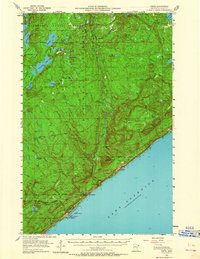
1955 Map of Tofte
USGS Topo · Published 1964About this map
Lake Superior dominates the southeastern boundary of this mid-century survey, where the settlements of Tofte and Schroeder are established along the rocky shoreline. The landscape is defined by the heavy timber and water resources of the Superior National Forest and Minnesota State Forest. Industrial development is evident through the Erie Mining Company Railroad, which cuts through the forest toward the newly developed Taconite Harbor, complete with its own powerplant and offshore features like Gull Island.
Find a feature on this map
58 named features on this map. Tap any name to fly to it.
Don’t see what you’re looking for? This feature index may not catch every label — zoom into the map to look around manually.
Map Details
Editions of this 1955 Tofte Map
3 editions found
Other maps of this area

1919 · Brule Lake
USGS Topo · 1:62,500

1919 · Lutsen
USGS Topo · 1:62,500

1954 · Two Harbors
USGS Topo · 1:250,000

1955 · Tofte
USGS Topo · 1:24,000

1955 · Schroeder
USGS Topo · 1:24,000

1955 · Tofte
USGS Topo · 1:62,500

1955 · Cramer
USGS Topo · 1:62,500

1956 · Little Marais
USGS Topo · 1:24,000

1956 · Finland
USGS Topo · 1:62,500

1957 · Two Harbors
USGS Topo · 1:250,000