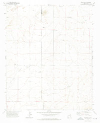
1973 Map of Tolar SW
USGS Topo · Published 1976About this map
White Mesa dominates the high plains of East-Central New Mexico, providing a clear window into the livestock and ranching infrastructure of the early 1970s. The landscape is defined by an extensive network of family-named water sources and landmarks, such as Noblitt Windmill, Lewis Windmill, and DeReno Windmill, which illustrate the vital importance of groundwater in this arid region. The presence of Blanco Cem suggests the historical footprint of earlier settlers in this corner of De Baca County. Geologic features including Sand Dunes near the northern boundary and the transition to The Mesa in the south provide a detailed portrait of the local topography. This survey also records the Base Line and section boundaries that dictated land ownership and development as the region transitioned through the mid-20th century.
Find a feature on this map
20 named features on this map. Tap any name to fly to it.
Don’t see what you’re looking for? This feature index may not catch every label — zoom into the map to look around manually.
Map Details
Editions of this 1973 Tolar SW Map
2 editions found
Other maps of this area

1954 · Fort Sumner
USGS Topo · 1:250,000

1954 · Clovis
USGS Topo · 1:250,000

1958 · Fort Sumner
USGS Topo · 1:250,000

1958 · Clovis
USGS Topo · 1:250,000
1967 · Watts Hill
USGS Topo · 1:24,000

1968 · Lomas Gatos
USGS Topo · 1:24,000

1968 · Taiban
USGS Topo · 1:24,000

1973 · Tolar
USGS Topo · 1:24,000

1973 · Krider
USGS Topo · 1:24,000
1973 · Gammil Well
USGS Topo · 1:24,000