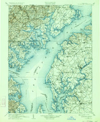
1908 Map of Tolchester
USGS Topo · Published 1934About this map
Chesapeake Bay dominates this early twentieth-century survey, revealing a landscape defined by the intricate waterways and shoreline necks of the Maryland coastal plain. The map traces the convergence of major estuaries including the Gunpowder River, Bush River, and the wide Sassafras River as they enter the bay. Notable for maritime researchers, the sheet identifies critical navigational aids like Fishing Battery LH and Sevenfoot Knoll LH, alongside the coastal defense at Fort Smallwood. Inland, the settlement pattern is linked by railroad stops such as Long Green Sta and Clayton Sta, while industrial history is marked at Harford Furnace. The map captures the region before modern bridge spans and suburban development, showing the prominence of family-named points and necks like Grove Neck and Stillpond Neck that once served as primary transit points for the river-and-bay economy.
Find a feature on this map
316 named features on this map. Tap any name to fly to it.
Don’t see what you’re looking for? This feature index may not catch every label — zoom into the map to look around manually.
Map Details
Editions of this 1908 Tolchester Map
4 editions found

Other maps of this area

1892 · Owensville
USGS Topo · 1:62,500

1892 · Annapolis
USGS Topo · 1:62,500

1893 · North Point
USGS Topo · 1:62,500

1893 · Gunpowder
USGS Topo · 1:62,500

1894 · Baltimore
USGS Topo · 1:62,500

1894 · Relay
USGS Topo · 1:62,500

1895 · Owensville
USGS Topo · 1:62,500

1898 · Choptank
USGS Topo · 1:125,000

1898 · Elkton
USGS Topo · 1:62,500

1898 · Tolchester
USGS Topo · 1:125,000